

History

This granite mortar stone was found south of Moreno Valley. The mortar was created by pounding seeds and other food materials with a hard stone pestle. The depth of these holes indicates quite a length of time that this same boulder was used by Native Americans for processing foods. (Moreno Valley Historical Society)

This boulder is located in the hills adjoining Moreno Valley. It is an interesting example of what archaeologists call a pit-and-groove style petroglyph which is an image carved in stone as opposed to a pictograph which is painted. Rock art is further evidence that Native Americans lived in the Moreno Valley area. (Moreno Valley Historical Society)

Begun in 1890 by the Bear Valley and Alessandro Development Company founded by Frank Brown, this is the entrance to the Moreno Tunnel located near the start of Redlands Boulevard. From here, water traversed through the Badlands a distance of 2,320 feet then on to reservoirs in Moreno Valley. (Moreno Valley Historical Society)

This is the completed exit of the Moreno Tunnel. When water first began to flow into the pipeline leading to Moreno in May, 1891, it was a celebrated event and was the catalyst that brought many investors to the area to establish farms and grow citrus and other fruits on a large scale. (Courtesy Riverside County Regional Park and Open Space District)

Large acreages of fruit trees were planted by the Alessandro Orange Grove and Fruit Company in 1891. However, there were more dry years than wet years and hard times came upon the water company as the water stopped flowing into Moreno. In 1895, the personal property of the fruit company was sold at auction in Moreno. (Courtesy Riverside County Regional Park and Open Space District)

This photograph was taken about 1902, when dry farming was becoming popular around the town of Moreno. It demonstrates the tediousness of baling hay before the influx of modern baling machinery. (Courtesy Viola Hamner)

Carl Lantz, seen here in 1905, works his orange grove east of Nason Street between Bay and Cottonwood Streets. By now, the trees are mature enough to produce a good crop of oranges. His chief market at this time was Redlands Foothill Groves, some distance away. (Courtesy David Lantz)

This cargo of hay has arrived near the railroad station along Highway 395 (today’s Old 215 Frontage Road) where it can be loaded into railroad cars and shipped to other parts of the state. Hay was also delivered directly to nearby towns like Perris and Riverside. Notice the two burros in the foreground who have no doubt detected the scent of hay. (Courtesy Winifred Banta)

Snow comes infrequently but this rare Sunnymead photograph shows that when snow does come, measures must be taken to protect the citrus crops. For years, smudge pots like these that burn oil were used to raise temperatures in the citrus groves; later large fans were installed to circulate cold air and deter freezing. Many people in the city today still remember the smell of orange blossoms every year. (Courtesy Ruby Lynn)

The original Midland School was built in 1894 just west of the Armada Post Office on the northwest corner of Alessandro Boulevard and Kitching Street. It was complete with a cupola and veranda fronting east on Kitching Street. The school burned down in 1910. (Courtesy Winifred Banta)

This is the Armada Post Office about 1910. Pictured from left are to right are: Mrs. Starbuck, Postmaster Starbuck and their daughter, Miss Starbuck. The post office was originally named Midland Post Office because it was midway between the Alessandro Post Office and the Moreno Post Office. However, postal authorities later named it Armada as they believed the surrounding mountains looked like a fleet of ships. The post office was discontinued in 1920. (Courtesy Jim Maxwell)

The second Midland School was built in 1910 and consisted of two rooms; one was a classroom and the other was reserved for church and community meetings. Note this school picture where students are ages 5 to 17. (Courtesy Jim Maxwell)

Thomas and Frances Edwards built this two-room house when they moved to Moreno in 1927. The house was later enlarged by moving in a building from the nearby Pisgah Sanitarium. Walter Edwards, their oldest son, is pictured standing beside his car. (Courtesy Mary Wheat)

Built on the site of the original Moreno School, this is the second Moreno School built in 1927-28. Each room had a pot belly stove and coal was stored in the school basement. The cupola is in the possession of the Moreno Valley Historical Society. (Courtesy Viola Hamner)

Camp Haan is at the center and Alessandro Flying Field is in the rear at upper left. During World War II, 1,500 acres of Hendrick Ranch land was sold to the U.S. government to establish Camp Haan, an Army antiaircraft artillery unit. On March 20, 1918, Alessandro Flying Training Field became March Field, named in honor of Second Lieutenant Peyton C. March, Jr., son of the Army Chief of Staff, who had been killed in a flying accident in Texas the previous month. Later, March Field became March Air Force Base encompassing more than 7,000 acres. (Courtesy Jim Maxwell)

This is a typical barracks at Camp Haan, which were moved or torn down after World War II. Midland school used some of the buildings. Others were used for houses, apartments or other facilities. Some Camp Haan buildings are still in use in Moreno Valley. (Courtesy Jim Maxwell)

By 1928, to accommodate the rising number of students and because the social life of the valley tended to revolve around the school, two wings were added to the Midland School building. Surplus barracks, a Red Cross building and mess hall enlarged the school when Camp Haan closed. The school was condemned in 1950 and was later torn down. The new City of Moreno Valley bought the school property on Alessandro Boulevard and built a library on the grounds. (Courtesy Jim Maxwell)

This house is being moved by Ben and Doug Hall during the 1930s from the Pisgah Sanitarium to Williams Street in Moreno just west of Redlands Boulevard to become the longtime home of Lawrence and Atha Keisling. The house is still standing today. (Moreno Valley Historical Society)

This is the Sunnymead childhood home of Alice Bradley, current President of the Moreno Valley Historical Society. This barracks from Camp Haan was purchased by Cap and Fay Dunagan in 1947, for $200. The government moved and delivered it. Many residences during this time were developed in this manner. Only a few remain standing today. (Courtesy Alice Bradley)

This photograph of Hugh’s Moreno Melon Market on the northwest corner of Redland’s Boulevard and Highway 60 was taken around 1938. Melons were popular with the locals and passersby as well. Hugh Bradley and his wife, Gertie, are standing at center with an unidentified couple at right and unidentified customer at left. (Moreno Valley Historical Society)

The first Alamo Market was built in Edgemont on the east side of old Highway 395 between Alessandro Boulevard and Bay Street. Owned and operated by the Crockers and the Osteens, there were a number of rentals in the rear and a small hotel above the market, the only hotel in town. Eventually, the market was torn down and a new one with the same name was built on the SW corner of Alessandro Boulevard and Highway 395. (Moreno Valley Historical Society)

Built in 1955, the Alamo Market was the first supermarket in Sunnymead. It was owned by Bill Crocker and Fred Chappell. Bill also owned the original Alamo Market in Edgemont. Of note is the siren atop the building which was used to call volunteer firefighters whenever a fire was reported. (Moreno Valley Historical Society)

A group of 4-H contenders show their projects at the Sunnymead Fair in 1950. Jim Maxwell is pictured fifth from the left. Jim’s dad operated the large Maxwell Ranch headquartered on Davis Street during this time. (Courtesy Jim Maxwell)
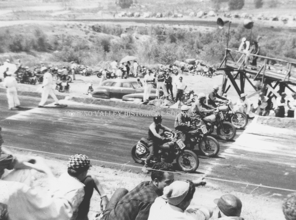
The start of a motorcycle race at a track located at the base of Box Springs Mountain just north of the future Riverside International Raceway. The oval racecourse lay along the base of the mountain. Motorcycle races were very popular here in 1955 and may have led the way to nearby auto racing. (Courtesy C.H. and Mary Wheat)

A motorcycle race is in session at the dirt racetrack at the southern end of Box Springs Mountain. The track was an oval but it incorporated a number of curves, as viewed here. This configuration made it popular. Note the tractor at far right which was used for dragging and preparing the ground between races. (Courtesy C.H. and Mary Wheat)
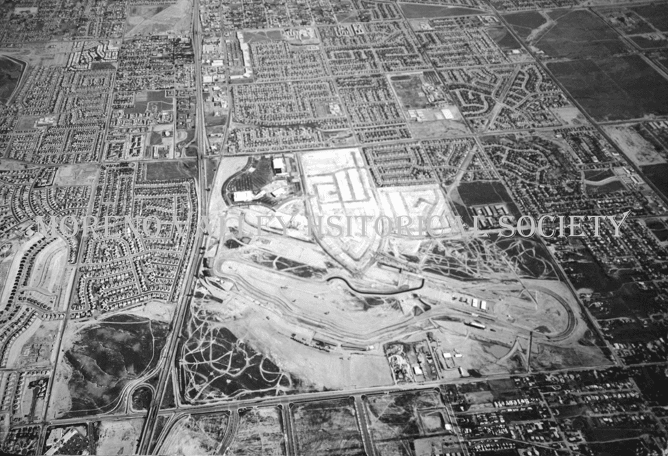
The Riverside International Raceway in Edgemont is bordered on the bottom (west) by Day Street, on the left (north) by Highway 60, on the top (east) by Frederick Street and on the right (south) by Cottonwood Avenue. Popular Turn 9, the last turn leading to the finish line, is shown at right. (Moreno Valley Historical Society)

Film legend Paul Newman carries an ice chest of cold drinks to his crew members at a pit garage during one of his races at Riverside Raceway in Edgemont. Newman became interested in auto racing while filming Winning in 1969. Newman loved racing so much that he spent his 80th birthday racing around Daytona. (Courtesy Tim Benson)